
Charlene Arney – Band Comparisons of Remotely Sensed Imagery
Currently working with revision @ 2012-07-10 18:04:40 by admin. Current version
Introduction
This project analytically compares the capabilities of WorldView 2 eight-band satellite imagery to that of QuickBird four-band imagery for use in vegetation mapping. Field data was collected to create a vegetation map that expands on the GAP analysis vegetation classes defined by USGS in February of 2006. Both types of imagery were be compared based on the refinement of these classes.Methods
GPS point locations of various plant types both native and alien were collected using Garmin GPS units GPS points were used to create a supervised classification in ERDAS to create a map of vegetation classes for the study area for each type of imagery. The WorldView 2 imagery was pan sharpened to be comparable with the pan sharpened QuickBird imagery.Data
QuickBird ImageryTaken between 10/22/2005 and 02/25/2006 .5 meter panchromatic resolution
2.4 meter multispectral resolution4 Multispectral bands
4 standard colors:
red, green, blue, and near-infrared 1 Worldview 2 Imagery
Taken in May of 2012
.5 meter panchromatic resolution
1.8 meter multispectral resolution 8 Multispectral bands
red, green, blue, and near infrared 1, coastal, yellow, red edge, and near-infrared 2
Conclusions
The eight spectral bands of the WorldView 2 imagery greatly increased the ability to distinguish between different species of vegetation. The results of this analysis reflect the observed vegetation types on the ground. The four additional band ranges in the WorldView imagery can be used to distinguish clusters of different alien species such as Iron Wood, Haole Koa, and Christmas Berry. The QuickBird imagery created a more pixilated vegetation cover that did not reflect the vegetation classes observed in the field. Although WorldView2 imagery is more expensive it is more effective in classifying vegetation types for this study area.Acknowledgements
Thanks to CSLUB, The National Botanical Garden, Dr.David Burney, Dr.Lida Burney, Dr.Christopher Lee, Dr.Suzanne Wechsler, Dr. Carl Lipo, Ted Ralston, Briton Voorhees, Paul Nesbit, Mike Ferris, Jake Kobalchij, Ryan Boarman, Bryan Moller, Kate Macklin, and Jesse YourshResearch was made possible by the National Science Foundation Research Experiences for Undergraduates Program NSF Award # 1005258 Geospatial Research and Mapping (GRAM)
References
2006 USGS GAP Analysis id=”attachment_2317″ align=”alignleft” width=”300″ caption=”Vegetation mapping of QuickBird and WorldView2 Imagery”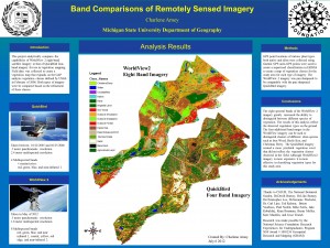 [1]
[1]
