
Hoouluia orthophotos, point cloud generation, and canoes
June 22, 2012Aloha kakou,
PAP (pole aerial photography) was not sufficient, but the KAP (kite aerial photography) imaging worked. I had previously mentioned the inadequate results from my PAP documentation of Hoouluia heiau. This morning, I started playing around with photographs taken from Chuck Devaney’s kite. Two hundred sixty-three photos were recorded on a Canon G12 attached to a 3 meters kite from an altitude of approximately 400 feet. Our archaeology group sequenced the photos in Agisoft Photoscan. Avery and Sam imported all of the photos into Photoscan software initially having issues with the output. I went for a minimal approach and sequenced 14 photographs resulting in a great image of the heiau (see below).
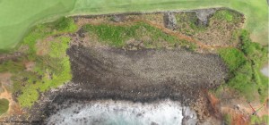
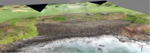
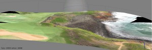
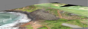
Sam is currently rerunning the large photo set and we should have some more refined images of the heiau from her work. However, I was able to export a point cloud from this basic sequence and will be working on DEMs (digital elevation models) to illustrate architectural attributes of this structure.
After spending most of the day in a computer lab, I was drafted away from my research group by the hydrology team for canoe help. We met with some of the members of Kukuiula Canoe Club and attached water sensors to the back of several outrigger canoes. The canoes towed the sensors for several miles, thus recording information about water temperature and salinity at different subsurface freshwater outlets along the coast. The canoes served well as research vessels and the hydrology team was happy with the data collection. Tomorrow, I will be back working with the arch group while we plan for more aerial photography and check out some new locations.
– John Thornton O’Connor